


Le Pradet les forts

jlnessy
User
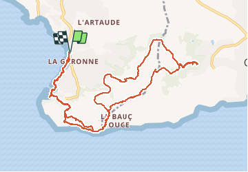

Length
14.5 km

Max alt
281 m

Uphill gradient
566 m
Km-Effort
22 km

Min alt
-1 m

Downhill gradient
564 m
Boucle
Yes
Creation date :
2020-02-06 08:24:24.401
Updated on :
2020-02-06 22:53:46.295
5h51
Difficulty : Easy

FREE GPS app for hiking
 SityTrail
IGN / Geographical institutes
SityTrail Plus
The world is yours!
About
Trail Walking of 14.5 km to be discovered at Provence-Alpes-Côte d'Azur, Var, Le Pradet. This trail is proposed by jlnessy.
Positioning
Country:
France
Region :
Provence-Alpes-Côte d'Azur
Department/Province :
Var
Municipality :
Le Pradet
Location:
Unknown
Start:(Dec)
Start:(UTM)
257898 ; 4775416 (32T) N.
Comments